John Crump House Historical Report, Block 17 Building 3B Lot 57 Originally entitled: "Colonial Lot 57 Block 17"
Colonial Williamsburg Foundation Library Research Report Series - 1327
Colonial Williamsburg Foundation Library
Williamsburg, Virginia
1990
 [Copy of Deed]
[Illustration]
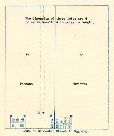
PHOTOSTAT COPY OF THE WILLIAMSBURG PLAT IN "WILLIAMSBURG THE OLD COLONIAL CAPITOL" BY LYON G. TYLER
P. 204 - Wills & Inventories 1740-46
Suit for Trespass
Penman Vs Burdette.
 Photograph D.O.G. Street
 RED LION
from picture loaned to Mr. Kendrew by Miss Annie Galt. Date of picture given as 1892
To: Mr. Cary Carson
Mr. Harold Gill
Mrs. Redpath
From: Paul Buchanan
Re: John Crump House
Block 17, Building 3B
1. PB - What's the logic of preferring 1830's photograph over [illegible]
2. A[illegible]
I wish to thank you for showing me the drawing of Mr. Reed's Store (c.1779) by Fedor Vasil'evich Karzhavin, which was sent to you by Mr. J. Dane Hartgrove.
This drawing must be the, now reconstructed, John Crump House. From 1773 until 1780 Mr. Henry Nicholson owned this building but he did not live in it. We do not know who rented it. Judging from the drawing I would assume that Mr. George Reid rented the west (left) third of the building.
We have two photographs and a drawing of this building just before it was demolished in 1893.
There are a few differences between the Karzhavin drawing and the 1890's photographs: the number of dormer windows, the number of first floor windows, the location of the center chimney, the cellar windows shown on the drawing are shown solid brick on the photographs. The west door hood is missing in the photographs.
I do not think that the reconstructed building should be changed as it conforms to the photographs
Drawing c 1779, Photographs c 1890 Reconstruction to 18th c. What's the logic of preferring 1890's photograph over c 1779 sketch?
The roof drawn by Karzhavin just below the pyramid could be either the Wren Building or the Public Hospital. The little three bay building in the lower right hand corner cannot be identified.
P.B.
Copy to:
Mr. R. E. Graham
Mrs. R. Goff
Mrs. C. Schlesinger
To: Mr. Cary Carson
Mr. Harold Gill
Mrs. Redpath
From: Paul Buchanan
Re: John Crump House
Block 17, Building 3B
I wish to thank you for showing me the drawing of Mr. Reed's Store (c.1779) by Fedor Vasil'evich Karzhavin, which was sent to you by Mr. J. Dane Hartgrove.
This drawing must be the, now reconstructed, John Crump House. From 1773 until 1780 Mr. Henry Nicholson owned this building but he did not live in it. We do not know who rented it. Judging from the drawing I would assume that Mr. George Reid rented the west (left) third of the building.
We have two photographs and a drawing of this building just before it was demolished in 1893.
There are a few differences between the Karzhavin drawing and the 1890's photographs: the number of dormer windows, the number of first floor windows, the location of the center chimney, the cellar windows shown on the drawing are shown solid brick on the photographs. The west door hood is missing in the photographs.
I do not think that the reconstructed building should be changed as it conforms to the photographs.
The roof drawn by Karzhavin just below the pyramid could be either the Wren Building or the Public Hospital. The little three bay building in the lower right hand corner cannot be identified.
P.B.
Copy to:
Mr. R. E. Graham
Mrs. R. Goff
Mrs. C. Schlesinger
To: The Administrative Officers
From: The Committee on Names of Houses
Re: Establishment of new name for "The Red Lion" - Block 17, Building 3B
The Committee on Names of Houses unanimously approves the adoption of the official name "John Crump House" for the present "The Red Lion", Block 17, Building 3B. The outbuildings shall also be designated as "John Crump Kitchen", "John Crump Stable", etc. We recommend approval by the Administrative Officers.
A. E. Kendrew
S.P. Moorehead
E. M. Riley
Approved [check mark]
ACTION:
Disapproved
Date 1957-03-27
CHH
C. H. Humelsine
Department of State
Washington, DC 20520
February 5, 1979
Mrs. John Redpath
Group Visits
The Colonial Williamsburg Foundation
Drawer C
Williamsburg, VA 23185
Dear Mrs. Redpath:
Here is a Xerox of the drawing I told you about after the seminar on Friday. I mistakenly told you that it was of Wright's store; as you can see, Karzhavin has labelled it "Mr. Reed's Store".
Fedor Vasil'evich Karzhavin visited Williamsburg twice, the first time from May, 1777, to January, 1780, and the second time from September, 1784, to April, 1787. For a sketch of his American travels, see Nikolai N. Bolkhovitinov, The Beginnings of Russian-American Relations 1775-1815, translated by Elena Levin (Cambridge, Massachusetts and London, England: Harvard University Press, 1975). The Soviet side has provided us with no date for Karzhavin's drawing, but I would tentatively put it in the 1777-1780 period because he spent much of his time in Williamsburg then, while he lived in Smithfield, Virginia, for at least part of his 1784-1787 visit.
The original of the drawing is in the Manuscript Section of the Saltykov-Shchedrin State Public Library in Leningrad. The rest of the archival citation is: f. F.V. Karzhavina., bez No.,l. 1.
If I can be of any assistance to you regarding Karzhavin, please contact me.
Sincerely,
J. Dane Hartgrove
Department of State
Washington, DC 20520
February 5, 1979
Mr. Harold Gill
Department of Research
The Colonial Williamsburg Foundation
Drawer C
Williamsburg, VA 23185
Dear Mr. Gill:
Your name was given to me by Ms. Pat Gibbs as the person to contact regarding some Williamsburg residents I have been trying to identify.
I am one of the American editors of a joint US-USSR documentary collection on early Russian-American relations. Perhaps the earliest Russian traveller in the United States was Fedor Vasil'evich Karzhavin, who spent much of the period 1777-1780 in Williamsburg. We know that Karzhavin was a friend or acquaintance of a number of prominent residents of Williamsburg, including George Wythe and Bishop James Madison. However, Karzhavin's references to other Williamsburg residents who were less well-known have left us in need of your help.
We know that in 1779, Karzhavin was living In the Williamsburg home of a Captain Laporte. In that same year, he helped a French merchant named Venel transport his goods by water into distant forests in order to prevent their destruction by the forces of John Goodrich. Karzhavin also made a drawing, which he labelled "Mr. Reed's Store" in "Wmsbg", of which the Soviets have sent us a copy for use as an illustration. The names Dormois, Mangone, Bernard, and Oster (probably Martin Oster, the French vice-consul for Virginia) also appear in Karzhavin's correspondence.
If you have any information on the lives, occupations, etc. of any of the individuals mentioned in the previous paragraph, we would very much appreciate hearing from you. I for one have great respect for the knowledge that has gone into Colonial Williamsburg, and I hope you have something to share with us.
Sincerely,
J. Dane Hartgrove
COLONIAL LOT 57
Block 17
COLONIAL LOT 57
Block 17
LOCATION:
Colonial Lot 57 is located on the north side of Duke of Gloucester Street near the Capitol. On Tyler's adaptation of late eighteenth and early nineteenth century plats of Williamsburg, the lot is designated as "Crump" and also "57".
IN SUMMARY:
On May 16, 1713, trustees of Williamsburg granted two lots on the north side of Duke of Gloucester Street to Francis Sharp, with the stipulation that a house or houses must be erected on the two lots, 57 & 58 within twenty-four months or the lots would revert to the city. Sharp, evidently, did not build as the trustees again granted these lots to Sharp in 1717 with the same understanding. Sharp built on the lots within the prescribed time for the property was still in his ownership at his death (1740). Sharp, an ordinary keeper, made a will in which he bequeathed to his son, John, "the House or Tenement now in the Occupation of Roadwell a Shoemaker" [lot 57]. In 1742 Sharp leased the property to Thomas Penman, carpenter and tavern keeper for seven years. . . "a Mansion house and a Billyard house" are mentioned in the lease with certain other stipulations on both parties as to buildings to be erected. In October 1742 the property was conveyed to Henry Wetherburn, ordinary keeper. Penman continued to rent the property from Wetherburn. In 1743 Seth Seekright "Lessee of Thomas Penman" sued John Burdett (who occupied as lessee of Thomas Pattison, the property to the east (Lot 58) for trespass. A measured drawing was made by a surveyor which was inserted into the York County Court Records. Following Wetherburn's death, (1760) Edward Nicholson, inherited the property after the death of Wetherburn's wife. (However, she demanded her dower and Nicholson came into this lot soon after Wetherburn's death.) Henry Nicholson, the next owner was followed by Henry W. Nicholson who conveyed it in 1789 to Samuel Crawley, and the, shortly, to John Crump, tavern keeper.
The Frenchman's Map of Williamsburg (1782) shows buildings flush to the main street with dependencies toward the north. The Bucktrout Map (1807) and the College Map (1791?) indicate "Crump" and "Lot 57".
In 1802 the property was insured by Crump and Esther Whitfield. The buildings were "40 [48?] by 27 feet of wood one story high valued at $1000." In 1807 Robert Anderson became the owner. The name of the tavern was changed from "Crump's" to "Union Tavern" in 1808-1810. Anderson was owner of ⅔ part and Edward Teagle of ⅓ part in 1815. During Anderson's and Teagle's ownerships of the property it was rented to several sets of store keepers. In 1823 Elizabeth Bray held ⅓ part. In 1826 Thomas Foster held ⅓ part. In 1830 Anderson held the entire lot. In 1853 Robert Saunders had become owner of ⅔ part and Thomas 0. Cogbill of ⅓ part. The property was occupied by a number of renters-mostly store keepers though a sadler and cabinet maker were there for a short period. From 1853 to 1889 the property continued to be owned by two parties: John Blassingham ⅔ and Cogbills ⅓; Miranda Wall ⅔ and Maurice Donnegan ⅔; Cogbills ⅓. In 1889 M. F. Timberlake was whole owner. He was followed by Edward W. Maynard, Chester Evans, Peninsula Realty Corporation, J. H. Pierce (north) and Mrs. George Bryn (south), and Williamsburg Restoration 1927.
Insurance policies (ten in all) signify that the property was about the same in dimensions from 1802 to 1830. In 1830 it was given as "27 feet by 32." Other insurance policies, 1838-1860, fail to give dimensions but indicate size and shape of buildings with divisions.
For further details of title and ownerships, see: body of the report to follow.
| Date | Owned By | Date | Occupied By | Profession |
|---|---|---|---|---|
| 1717 | FRANCIS SHARPE from Trustees | Ordinary | ||
| 1739 | Rhoadwell | shoemaker | ||
| 1740 | JOHN SHARP by will of father | Thos. Penman | carpenter & tavern keeper | |
| 1742 | HENRY WETHERBURN | 1742 | Thos. Penman | |
| 1749 | Thos. Penman | |||
| 1761 | EDWARD NICHOLSON | |||
| 1773 | HENRY NICHOLSON | |||
| 1780 | HENRY W. NICHOLSON | |||
| 1789 | SAML. CRAWLEY | 1789 | E. Ewing & John Bryan | |
| 1789 | JOHN CRUMP | |||
| 1796 | JOHN CRUMP | TAVERN KEEPER | ||
| 1802 | JOHN CRUMP & ESTHER WHITFIELD | 1802 | Crump & Whitfield | |
| 1805 | JOHN CRUMP | 1806 | John Crump | |
| 1806 | ROBT. ANDERSON | 1807 | John Crump | "Union Tavern" |
| 1814 | Edward Teagle & Geo. Bray | |||
| 1815 | ROBT. ANDERSON ⅔ part (east) | |||
| EDWARD TEAGLE ⅓ part (west) | 1815 | Edward Teagle & Geo. Bray | ||
| 1816 | EDWARD TEAGLE ⅓ part | |||
| ROBT. ANDERSDON ⅔ part | ||||
| 1821 | Wm. Lee | store | ||
| Sarah Hughs | store | |||
| 1823 | ELIZABETH BRAY ⅓ part | |||
| ROBT. ANDERSON ⅔ part | 1823 | Sally & Eve Hughs ⅓ | store | |
| Mr. Banks ⅓ | ||||
| John & E. Ball ⅓ | store | |||
| 1826 | THOMAS FOSTER ⅓ | |||
| ROBT. ANDERSON ⅔ | ||||
| 1829 | Thomas Moore | store | ||
| 1830 | Thomas Moore | store | ||
| 1830 | ROBT. ANDERSON (whole lot) | 1830 | E. Ball | store |
| 1832 | Wm. Wicker | store | ||
| 1832 | Aug: C. Hubbard (front room) | store | ||
| 1837 | Aug: C. Hubbard | store | ||
| 1838 | James T. Bowery ⅓ | dwelling | ||
| Date | Owned By | Date | Occupied By | Profession |
| M. J. Orrills's rep. ⅔ | store & Dwel. | |||
| 1853 | ROBT. SAUNDERS ⅔ (east) | 1846 | ||
| James T. Bowery ⅓ | dwelling | |||
| 1853 | W. Wright | saddler | ||
| THOS. O. COGBILL ⅓ (west) | 1853 | Allen Lindsey ⅓ | cabinet shop | |
| John M. King ⅔ | store | |||
| 1859 | JOHN BLASSINGHAM ⅔ (east) | 1859 | store | |
| ELEANOR E. COGBILL ⅓ (west) | ||||
| 1860 | JOHN BLASSINGHAM ⅔ (east) | 1860 | Joseph Walthall | store |
| ELEANOR E. COGBILL ⅓ (west) | 1860 | school house | ||
| 1865 | MIRANDA WALL ⅔ (east) | |||
| 1866 | MAURICE DONNEGAN ⅔ (east) | |||
| ELEANOR C. COGBILL ⅓ (west) | ||||
| 1889 | M. F. TIMBERLAKE | |||
| 1894 | EDWARD W. MAYNARD | |||
| 1916 | CHESTER EVANS | |||
| 1916 | PENINSULA REALTY CORPORATION | |||
| 1921 | J. H. PIERCE (northern portion of lot) | |||
| 1924 | MRS. GEORGE A. BRYN | |||
| 1927 | W. A. R. GOODWIN for Williamsburg Restoration | |||
COLONIAL LOT 57*
Block 17
LOCATION:
Colonial Lot 57 is located on the north side of Duke of Gloucester Street near the Capitol. On Tyler's adaptation of late eighteenth and early nineteenth century plats of the city of Williamsburg the lot is designated as "Crump" and also "57". See: map on opposite page.
HISTORY:
On May 16, 1713 Trustees for building the City of Williamsburg granted two lots of land on the north side of Duke of Gloucester Street to Francis Sharp.1
[May 16, 1713]
THIS INDENTURE made ye 16th day of May in ye twelfth Year of ye reign of ye Sovereign Lady Ann by ye grace of God of Great Brittain, France, & Ireland Queen defendr of ye faith &c And in ye Year of our Lord One Thousand Seven hundred & Thirteen BETWEEN ye Feoffees or Trustees for ye Land appropriated for ye Building & Erecting ye City of Williamsburgh of ye One part & Francis Sharpe of ye County of York of ye Other part WITTNESSETH that whereas ye sd Francis Sharpe by One Lease to him ye sd Feoffees or Trustees bearing date ye day before ye date of these Presents is in [blur] & peaceable possession of ye premisses hereon hereafter granted,... but more Especially for & in consideration of Thirty Shillings of good & lawfull money of England to them in hand paid at & before ye Ensealing & delivery of these Presents... HAVE granted, bargained, Sold, remised, released & confirmed, & by these Presents for themselves, their heirs & Successrs...do grant, bargain... unto ye sd Francis Sharpe Two certain Lotts of Ground lying on ye North side of ye Duke of Gloucester Street in ye sd City of Williamsburgh designed in ye Plott of ye sd City by these figures 57 & 58 with all Woods thereon 2 growing or being together with all Profits, Commoditys, Emoluments & Advantages whatsoever to ye Same belonging or in any wise appertaining TO HAVE & TO HOLD ye sd granted Premisses & Every part thereof with ye Appertenances unto ye sd Francis Sharpe & to his heirs for Ever .... under ye limitations & reservations hereafter mentioned: That is to say that if ye sd Francis Sharpe his heirs & Assigns shall not in ye Space of Twenty four months next Ensuing ye date of these Presents begin to build & finish upon Each Lott of ye sd granted Premisses One good dwelling house or houses of Such dimensions & to be placed in such manner as by One Act of Assembly made at ye Capitol ye 23d day of October 1705 intituled an Act continuing ye Act directing ye building ye Capitol & City of Wmsburgh &c... Then it shall & may be lawfull to & for ye sd Feoffees or Trustees & their successrs ye Feoffees or Trustees for ye Land appropriated for ye building and Erecting ye City of Wmsburgh for ye time being into ye sd granted Premisses & Every part thereof with ye Appurtenances to Enter & ye Same to have again as of their former Estate... In Wittness whereof Jno Clayton & Wm Robertson Gentt Two of ye sd Feoffees or Trustees have hereunto sett their hand & seals ye day & Year above written
John Clayton Seal
Wil Robertson SealSigned, Sealed & Delivered in ye Presence of
Michl Archer
C JacksonMay 16th 1713 Then received of Francis
Sharpe ye Sum of Thirty Shillings .....
pr Wil Robertson…
At a Court held for York County 21 Septr 1713 Wm Robertson Gentt One of ye Feoffees or Trustees for ye Land appropriated for ye building & erecting ye City of Wmsburgh Presented & acknowledged ye within Deed of Release for Two Lotts of ye sd Land to Francis Sharpe & on his mocon they are Admitted to Record
Test Phi: Lightfoot Clcur1Truly Recorded
Test Phi: Lightfoot ClCur.
Evidently, Sharpe failed to comply with the building clause in the deed--that a house be erected on each lot within 24 months-for the lots reverted to the trustees. The same lots were again conveyed to Sharp in 1717: 3.
[May 2, 1717]
[Trustees of the City of Williamsburg
...Two certain Lotts of Ground in the City of Wmsburgh designed in ye Platt of ye sd City by the figures 57 and 58 with all Woods thereon growing or being... [must build within 24 months upon each lot one good dwelling house or houses according to Act of Assembly of October 23, 1705 or trustees will enter same as of their former Estate]
to
Francis Sharp of York County
Consideration: 30 shillings money of Virginia]
John Clayton (Seal)1
Wil Robertson (Seal)[Recorded York County Court May 20, 1717]
Sharp built on the lots within the prescribed time for the property was still in his ownership at the time of his death (1740).
In 1718 Sharp was granted a license to keep an ordinary in the city. It is believed that Sharp's ordinary was kept in the house on lot 57 which was later described as being "commonly known by the name of Francis Sharp's in the city of Williamsburg."
The record of Sharp's license in 1718 reads:
May 19, 1718
KNOW ALL MEN by these presents that We Francis Sharp James Dowling & Joseph Wade of the County of York are held & firmly bound to our Sovereign Lord George by the Grace of God of Great Britain France & Ireland King Defender of the faith &c in the sum of Ten thousand pounds of Tobo Convenient in the sd County of York To which payment/well & truly to be made to our Sovereign Lord the King his heirs, & successors; We bind Ourselves & every of our heirs Exerrs & Adminrs joyntly & Severally firmly by these presents Sealed with our Seals dated this 19th day of May 1718.
THE CONDITION of this Obligation is Such that Whereas the above bound Francis Sharp hath this day an Order Granted him for a Lycence to keep an Ordinary at his now dwelling house in Williamsburgh for the year next ensueing if therefore the sd Francis Sharp Shall constantly find provide in his Said ordinary good wholesome & cleanly lodging & diet for Travellers & stabbleage fodder & 4. provender for their horses or pasturage & provender (as the Season Shall require) from the date of these presents for & during the Term of one Year, and Shall not suffer any unlawful gaming in his house, nor on the Sabbath day Suffer any person to Tipple or drink more than is necessary. Then this Obligation to be void else to remain in full force & virtue ....1
In 1719 Sharp renewed his license. No further licenses were issued to him, nor do we know when he moved from Williamsburg to Surry County. When he wrote his will in that county on August 14, 1739, he was well established in Surry with property but still held his property in Williamsburg. A portion of Sharp's will which concerns his property in Williamsburg is given below:
[August 14, 1739]
[Will of Francis Sharp]
... Imprimis, I give and devise to my son ffrancis Sharp the Lot of Land House and Appurtenances in the City of Williamsburg that Mr: Burdet now liveth upon Adjoining to the Capitall Square (Excepting thirty five feet to be laid off out of the East end of ye said Lot) ... [This is Lot 58]
...
Item I Give to my Son John Sharp the House or Tenement now in the Occupation of Roadwell a Shoemaker it lying in the City of Williamsburg and the plantation whereon I now live upon that is now called by the name of Young Thomas Smiths...
Item I give and devise to my Son William Sharp the remaining part whereon I live now... and I also give to my said Son William Thirty five feet out of the East End of ye Lot given to my Son Francis Whereon Mr Burdet in Williamsburg now lives [Lot 58]2
In 1742 John Sharp who had inherited the house on Lot 57 (occupied by "Roadwell a Shoemaker" in 1739), leased the property to Thomas Penman, carpenter, for seven years. The deed of lease stated that it was then in the occupation of Thomas Penman: 5.
6.[July 17, 1742]
[John Sharp, planter of Surry County
... All that Lott and houses commonly known by the Name of Francis Sharps in the City of Wmsburg decd now in the possession of the above said John Sharp Son of the said Francis decd and now in the Occupation of the said Thomas Penman To have and to hold [unto the said Thos Penman his heirs Extors...] for the full Term of Seven Years from the first day of this Instant fully to be Compleated and ended With full privileges...tend & Occupy all or any part of the Ground of the said Lott Yielding & paying unto the said John Sharp his Extors & Admors for the said demised premises the Yearly rent of Eight pounds Currt Money of Virginia until such time as there shall be a Convenient Brick Chimney built either to the present Billyard house wch is on the sd Lott or to a house wch the said Penman is to build Twenty feet by Sixteen feet at the said Penman's Costs Excepting the said within mention'd Brick Chimney wch is to be at the charge of the sd John Sharp but in Case the said Sharp should not Comply in getting the said Billyard room in Order aforesaid for the Use of the said Penman then the said Sharp shall build the sd Penman a Convenient Kitchen Sixteen feet by Twelve wth a Brick Chimney on sd Lott for the Use of said Penman the sd Sharp is further to pull down the back shed wch is now adjoining to the Mansion house on said Lott and rebuild it two feet wider and pale in the sd Lott and put the sd houses in good Tenantable repair by next March And the sd Sharp is to build the sd Penman a Sufficient Smoke house by Christmas next eight feet Square after the said buildings & repairs is fully Compleated by said Sharp then the sd Penman his heirs Extors &c is to pay unto the said Sharp his heirs Extors &c the Years rent of Ten pounds Currt Money wch said Sum is to be paid half-Yearly and the sd Penman doth oblige himself his heirs &c to keep the said premisses in Tenantable repair during the said Term And the said Sharp doth oblige himself his heirs &c in the penalty of Ten pounds Currt money to perform the aforesd Agreemt In Witness whereof each party have set their hands, & Seals The day & Year within mention'd
to
Thomas Penman, carpenter of Williamsburg
Consideration: 8 pounds yearly rent for seven years if certain conditions are met by both parties]
John I Sharp (L.S.) his mark
Thos Penman (L.S.)1Sealed & delivered in
presence of
John Parker
Andw Anderson
John Mundell
John Taylor
John Kendal[Recorded in York County Court, July 19, 1742]
This lease is of great interest in that it mentions certain buildings on the lot: "the Mansion house" and a "Billyard house". Under certain provisions--to be met by both parties--a brick chimney was to be erected to the billiard room for the use of Penman, and a house 20 feet by 16 feet was to be built. If the chimney was not built, then Sharp must build a kitchen 16 feet by 12 feet with brick chimney on the lot for Penman's use. Also, Sharp was to pull down the back shed adjoining the Mansion house and rebuild one two feet wider, and pale in the whole lot and put all houses in good and tenantable repair by March 1742/43. Sharp was to build, also, a smoke house by Christmas, 1742, 8 feet square after the other building and repairs had been fully completed. Penman agreed to pay a rent of ten pounds after all these conditions had been met but agreed to pay eight pounds for seven years prior to the complete completion of the conditions.
It looks as though Sharp, probably, never got around to making the changes which he had agreed to and we do not know if Penman completed any of the building according to his agreement. Some of it could have been done. However, on October 1, 1742, John Sharp conveyed the property in fee simple to Henry Wetherburn, ordinary keeper of Williamsburg:
[October 1, 1742]
[John Sharp, planter of Surry County
... All that Messuage Tenement Lott and half Acre of Land Situatte lying & being upon the Duke of Gloucester Street in the said City of Wmsburg and bounded on the East by the Lott lately purchased by one Thos Pattison of Jacob Sharp Brother of the said John Sharp on the South by the said Duke of Gloucester Street on the West by the Lott of Rachel Rhodewell and on the North by Nicholson Street the said premisses being now in the tenure and Occupation of one Thomas Penman and Marked in the plan of the said City of Wmsburg with the Number (57) 7. Number (57) And all houses...in fee Simple...forever...
to
Henry Wetherburn, ordinary keeper, Williamsburg,
Consideration: £80 current money of Virginia]
John Sharp (L.S.) his mark
[blurred]1[Recorded York County Court February 21, 1742/43]
This indenture conveys the information that Pattison was on Lot 58, Rhodewell on Lot 56 and Penman was still occupying Lot 57. Penman must have continued to rent the property after Wetherburn's acquisition of it. The fact that there was a suit in February, 1753, by Wetherburn as plaintiff and Penman as defendant, leads us to this assumption. On that date, the Court of York County decided that "Penman must pay to Wetherburn £8.9.1 by Order of Court dated January 15, 1753."2 It does not state any further details as to why Penman owed Wetherburn. However, since Penman had agreed in 1742 to lease Sharp's property for 28 per year for seven years--, the amount which Penman was ordered to pay to Wetherburn may have been for rent.
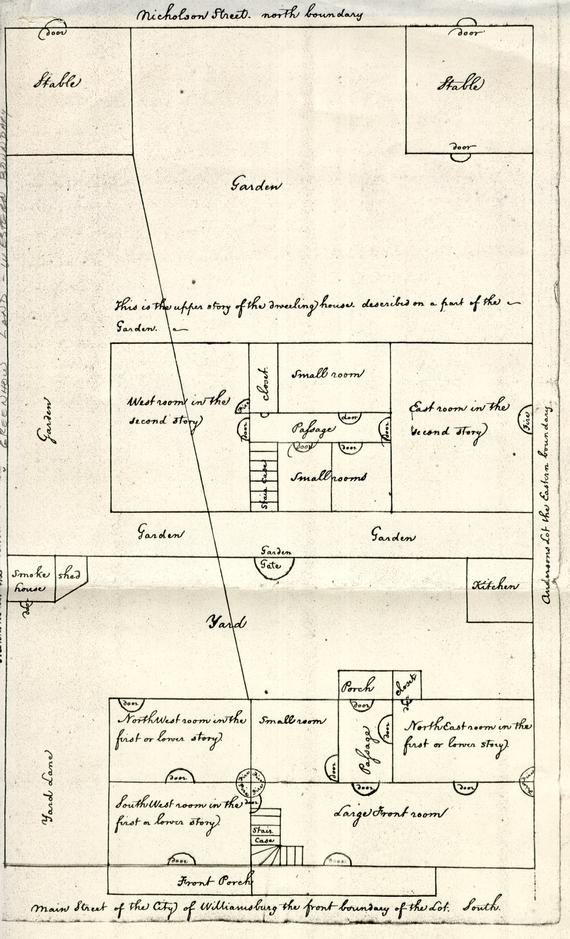
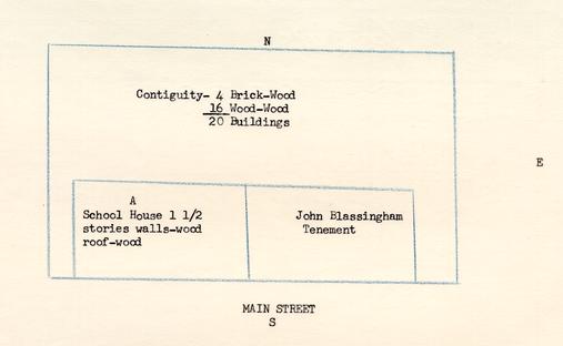
We know that Penman was occupying the property in 1743. In that year Seth Seekright "Lesse of Thomas Penman" sued John Burdett who occupied as lessee of Thomas Pattison, the property to the east (Lot 58) for trespass. During the suit surveyors measured the lot and made a sketch of the properties involved. See: sketch on opposite page. Details of the court record concerning the suit follows:
9.[May 16, 1743]
[Seth Seekright - Plaintiff
Lessee of Thomas Penman
vs.
John Burdett - DefendantIn the Ejectione Firma between Seth Seekright lessee of Thomas Penman, Plaintiff and John Burdett, Defendant, this 8. day came the parties aforesaid by their attornies and waived the tryal by jury and submitted the matter to the opinion of the Court, which is, that the black line in the surveyors plot returned in this cause is the bounds of the Plaintiff's land in dispute. And that the Plaintiff hath sustained one shilling damage by occasion of the trespass and ejectment aforesaid. And it is considered by the Court that the Plaintiff recover against the defendant his term yet to come of and in one messuage one tenement and one lot or half acre of land with appurtenances situate, lying and being on the Duke of Gloucester Street in the City of Williamsburg as in the deed mentioned together with his damages aforesaid and also his costs by him about his suit in this behalf expended. And the said defendant in mercy etc.
And it is ordered that his Majesty's writ of Habere Fac's possionem issue to put the Plaintiff in possession of the premises.
And it is ordered that the surveyors plot and certificate returned in this cause be recorded and they are recorded as follows:
Surveyors Note:
In obedience to an order of York County Court dated the 16th of May 1743, I have surveyed the lot in dispute between Seth Seekright, lessee of Thomas Penman, Plaintiff and John Burdette, defendant, as each party directed, that is to say, the lot No. 57 claimed by the Plaintiff and the Lot No. 58 claimed by the defendant according to the above plan, by which it appears that the body of the defendants house stands about 8 feet on the plaintiffs lot. The prickt line A shows the bounds of Burdetts lot as held by Mr. Kerr, taking in ____ 14 feet from Penmans lot: and the prickt line B. taking about 4 ft. more, was lately a line of pales of Burdette.
Jos. Davenport - Surveyor City Wmsburg.In the action of Trespass between Thomas Penman, Plaintiff and John Burdett, Defendant, this day came the parties aforesaid by their attornies and thereupon came a jury to-wit: Andrew Anderson, Edward Baptist, John Goodwin, Jr. Wynne Edward Dobson, Edward Curtis, William Fuller, Edward Peters Edward Potter, James Goodwin, George Holloway and Hugh Orr, good and lawful men who were elected, tryd and duly sworn to say the truth in the matter in issue and upon their oaths they say that the defendant is guilty of the trespass in the declaration mentioned and they assess the damages of the Plaintiff by occasion thereof to 5 pounds.
Therefore, it is considered by the Court that the Plaintiff recover against the said defendant his damages aforesaid by the jurors aforesaid in form aforesaid assessed, and also his costs by him about his suit in this behalf expended and the said defendant in mercy, etc.1
Penman was still occupying the property in 1749. A deed to Lot 56 on June 17, 1749, indicates that Penman was still in possession of Lot 57. The deed describes the eastern boundary of Lot 56 as "the lot of Henry Wetherburn now in the Possession of Thomas Penman."1
In October, 1749, Robert Rose, minister, visited Williamsburg. In his Diary he recorded this item: "October 9, 1749... Spent the Evening in Mr Tod's lodgings where I slept these two nights being at one Penman's."2
We do not know whether Penman continued to rent from Wetherburn or not. There is no hint in Penman's will as to where he was living in 1759. He mentions "two lots lately purchased by me of Col. Philip Johnson" and "houses and lots in Williamsburg which I formerly purchased of Robert Stevenson and are now in the tenure and occupation of James Craig Jeweller."3
Wetherburn continued to own the property until his death. An item in the will of Wetherburn (probated on December 15, 1760) proves that Edward Nicholson was a nephew and inheritor after the death of the tavern keeper's wife:
[Ite]m. I Give and Devise to my Nephew Edward Nicholson the Reversion [of m]y Lands Tenements and Slaves given to my wife for her Life and all other m[?] Estate real or Personal of what Nature or kind soever in the whole wo --- ld to him and his Heirs forever...4
Edward Nicholson is thought to have been the son of Hannah Nicholson of Newcastle, England. He was dead by September, 1762.5 No will or 10. appraisment of his estate has been located in York County Records. However, there is record that Benjamin Weldon and Fleming Bates were appointed by the court as Nicholson's executors.1
At the sale of the personal property of Henry Wetherburn in 1763, the executors of Nicholson invested to the amount of £524.6.-."2 Following Wetherburn's death, Anne, the widow, went into York County Court and demanded her dower right.3 Four prominent Williamsburg citizens selected by the court allotted to the widow certain slaves, also lots 21 and 22 with the houses thereon.4 According to law, this demand of her dower right revoked the will and paved the way for Edward Nicholson and his heirs to inherit the rest of Nicholson's property at once. It seems reasonable to assume that Edward Nicholson or his heirs owned lot 57 after 1761. It is believed that neither Edward nor his son (or brother) Henry, ever lived on this lot. It was, evidently, leased to others. In 1780 Humphrey Harwood, Williamsburg brick mason and carpenter, charged repairs for the property in the city thus: "Benjamin Weldon (for Henry Nicholson's Estate )."5 In 1781, in the same account, Weldon is noted as "guardian of Henry Nicholson." As Henry Nicholson was dead in 1781, it is assumed that Weldon was appointed guardian of his son, Henry W[etherburn] Nicholson. A careful study of York County Records did not reveal anything more concerning the Nicholsons except that they were from James City County.6 This may explain the lack of legal evidence-- 11. such as, no guardian accounts or any deeds of conveyance of their property until 1789. Title to the property will be handled chronologically in the report.
In 1773 and again in 1779 the deeds to lot 56 mention "the lot of Henry Nicholson" as its eastern boundary.1
The Frenchman's Map of Williamsburg (1782) indicated a long building of about the same size as the house to the east of it -- "Burdett's Ordinary".2
Williamsburg land Tax Records for 1782 list Henry Nicholson as owner of "3 lots with tax value of £15".3 (Sometime prior to 1782 Nicholson had come into possession of lots 21 and 22; possibly by the death of Mrs. Wetherburn.) In 1785 Nicholson's lots are broken down into lot 1 valued at £5 and 2 lots which he sold to William Rowsay. (The first lot was lot 57, subject of this report.) In 1786 this lot is valued at £7 and in 1788 it is valued at £22.10- which seems to indicate that considerable changes or repairs must have been made by Nicholson. This seems to be a reasonable deduction, for when Nicholson sold the property in 1789, it was valued at £200. (To follow in the report).
As Nicholson owned 3 lots in the city from ca. 1782 to 1780, it is difficult if not impossible to know when repairs and refinishing was made to each lot. Harwood's accounts--detailed as they are--give no clear cut solution. A copy of these accounts is included in Illustration #3. We can only assume or guess except in the account of 1783 "Henry 12. Nicholson and Mrs Ann Craig" as this account mentions the "bull head".1
In 1773, and again in 1779, the deeds to Lot 56 mention "the lot of Henry Nicholson" as its eastern boundary.2
The house erected by Sharp (See: sketch dated 1743 opposite page 7 of the report) was enlarged at some time prior to 1782, the date of the Frenchman's Map, which indicated a long building of about the same size as the house to the east of it (Burdett's Ordinary). See: architect's drawing from the Frenchman's Map in Illustration #1 of this report.
In 1789 Henry W. Nicholson conveyed Lot 57 to Samuel Crawley:
[July 10, 1789]
[Henry W. Nicholson of James City County
... All that piece or parcel of land lying and being in the Parish of Bruton City of Williamsburg County of York bounded as follows: On the South by the Duke of Gloucester Street, on the West by the lot of William Nicolson on the North by Nicholson Street and on the East by the lot of David Meade and denoted in the Plan of the said city by the number 57 which said lot is at present in the occupation & Use of Ebenezer Ewing and John Bryan... All houses...
Sarah, his wife,
to
Samuel Crawley3
Consideration: 200 pounds current money of Virginia]
H Nicholson (L.S.)
Sarah Nicholson (L.S.)4[Recorded York County Court January 18, 1790]
Research failed to disclose anything further as to the business relationships of Ebenezer Ewing and John Bryan. There were several 13. John Bryan in Williamsburg. One was a silversmith.1
Crawley, evidently, did not hold the property, for the Williamsburg Land Tax record for 1789 indicates that it was conveyed by, Nicholson to John Crump: "1789 Henry Nicholson to Jno Crump ---- 1 lot --- $20."2
The above named Crump died ca 1790.3 A John Crump,4 probably, a son, had a lot in the city later. It is assumed that it was John Crump [jr] who owned the property in 1802 when he insured it thus: "MY Own buildings on the Main Street at the sd Place now occupied by 0urselves situated between Robert Greenhow and that of J. W. Dixon in the county of James City5...Dwelling house 40 [48] by 27 feet built of wood and one story high [valued] at $1000."6
In 1806 an insurance policy (#645) on the property to the west notes that "John Crumps Tavern" was a boundary.7
Also, in 1806 an agreement of trust was entered into by Crump, Robert Anderson and Leroy Anderson which reads as follows: 14.
16.[August 28, 1806]
[John Crump to Robert Anderson
THIS INDENTURE... Between John Crump of the City of Williamsburg of the first part, Robert Anderson of the same City of the second part, and Leroy Anderson of the same City mutually chosen by the aforesaid parties as their Trustee of the third part: Witnesseth that... John Crump and Mary his wife by deed bearing date on the fifteenth day of June eighteen hundred and five duly recorded in the District Court of Williamsburg did sell and convey unto Joseph Prentis Junior in Trust to secure the sum of $239.50 to Robert Anderson with other property therein named a certain house and Lot then and still in the occupation of the said John Crump situate lying and being in the said City of Williamsburg ... [abstract - Crump owes Anderson $727.30 which he honestly desires to pay to Robert Anderson]. NOW THIS INDENTURE WITNESSETH that the said John Crump... in hand paid by the said Leroy Anderson the receipt whereof the said John Crump doth acknowledge hereby and thereof acquit and discharge him the said Leroy Anderson, he the said John Crump hath granted, bargained, sold, aliened, enfeoffed and confirmed and by these presents DOTH grant, bargain, sell, alien enfeoff and confirm unto him the said Leroy Anderson and his heirs Executors and Administrators in fee simple forever all that piece parcel or Lot of Land before mentioned with the messuage or tenements thereon situate lying and being in the said City of Williamsburg and bounded by its known and reputed boundaries, being the same whereon he the said John Crump resides. Also one-half of that piece or parcel of land above recited which was sold to the said John Crump and Charles Z. Abraham by the said Aaron Abraham and Elizabeth his wife by Deed bearing date as aforesaid containing 55 Acres and fifteen poles situate lying and being in the County of York and at present occupied as a race field by the said John Crump and Charles Z. Abraham and all houses, woods, ways, waters, water courses, buildings, .... appurtenances whatsoever to the said house and lot and to the one half of the said tract of Land belonging or in any wise appertaining and the reversion and reversions remainder and remainders, rents issues and profits thereof and of every part and parcel thereof and all the estate right title, interest, use... and property claim and demand whatever of him the said John Crump of in and to the same. TO HAVE AND TO HOLD the said house and lot and the said one half of the said piece or parcel of Land hereby conveyed with all and singular their appurtenances unto him the said Leroy Anderson his Heirs and Assigns forever to the only proper use and behoof of him the said Leroy Anderson his Heirs & Assigns forever. IN TRUST nevertheless and this Indenture is upon this express condition that he the said Leroy Anderson at any time after the first day of December next when he the said Robert Anderson or his Heirs shall require it, shall sell and dispose of the said house and lot and the one half of the said piece or parcel of Land with all and singular their 15. appurtenances for ready money at public auction to the highest Bidder after giving ten days previous notice of the time and place of such sale by advertisement posted at the Raleigh Tavern door in the City of Williamsburg and shall duly convey the same by sufficient legal assurances to the purchaser or purchasers thereof at such sale in fee simple. And the said Leroy Anderson for himself and his Heirs doth hereby covenant and agree to and with them the said John Crump and Robert Anderson that he the said Leroy Anderson will sell and dispose of the aforementioned premises with their appurtenances at public auction for ready money to the highest Bidder after giving ten days previous notice by advertisement posted as aforesaid and that he will well and truly pay and satisfy the said Robert Anderson the nett amount of such sale after paying the necessary expences. And the said John Crump for himself and his Heirs doth hereby covenant and agree to and with him the said Robert Anderson his Heirs and Assigns that he the said John Crump will well and truly pay and satisfy unto him the said Robert Anderson the aforesaid sum of $727.30 on or before the first day of December next. And the said Leroy Anderson for himself and his Heirs doth hereby covenant and agree to and with them the said John Crump and Robert Anderson and their Heirs that he the said Leroy Anderson will not sell or dispose of the aforesaid premises hereby conveyed but on the request of him the said Robert Anderson or his heirs and then only in the manner herein before particularly directed, And the said Leroy Anderson for himself and his Heirs doth hereby covenant and agree to and with him the said Robert Anderson his Heirs and Assigns that he the said Leroy Anderson will sell and dispose of the aforesaid premises at any time after the first day of December next when he the said Robert Anderson shall require it. [abstract - John Crump agrees with Leroy Anderson that he] the said John Crump & his Heirs the aforesaid House and Lot in the City of Williamsburg and the said one half of the aforesaid tract or parcel of Land with all and singular their appurtenances unto him the said Leroy Anderson and his Heirs and against the lawful claim and demand of him the said John Crump and his Heirs and against the lawful claim and demand of all and every person and persons whomsoever will Warrant and by these presents forever defend...
Deed of trust][Signed by]
John Crump (Seal)
Leroy Anderson (Seal)
Ro. Anderson (Seal)1[Acknowledged in York County Court February 16, 1807]
[Recorded York County Court March 20, 1809]
In 1807 Williamsburg Tax Records indicate that Anderson was the owner: "Robert Anderson... 1 lot via Crump... $90."1
At this period the name of the tavern was changed to Union Tavern. Anderson's Account Book (1806-1808) indicates that he had minor changes made to the property thus designated:
| Sundries dr To Merchandise Account | |
| Union Tavern for 39 chestnut posts a 25 ea.- | [$]7.50 |
| for 145 oak rails a 4- | 8.06 |
| these are for the dividing line between Morrison & myself | |
| Union Tavern dr To William Armistead for morticing and putting up | |
| 29 pannels posts and rails between Morrison & myself | 9.67 |
| George Morrison dr To Union Tavern for half expence of our division fence- | 12.61 ½2 |
In March, 1809, Anderson noted in his Account Book that he had "rented my house to John Crump until 1 december next at the rate of one hundred dollars per annum to commence the ls day of April."3
In 1810 Anderson wrote to Joseph Prentis in Suffolk: "March 18, 1810... I am now in my own dwelling the Union Tavern."4 The same month and year Anderson recorded in his Account Book: "UNION TAVERN dr To Cash Account paid to carpenters 50 & for nails 50...$1."5
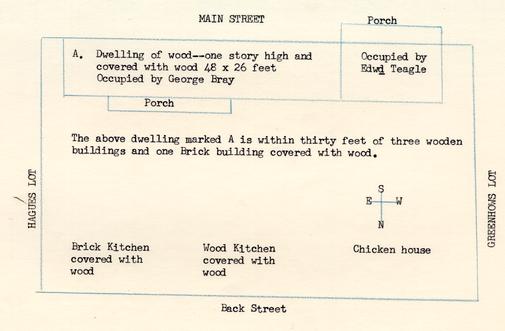
When Anderson revalued the buildings in 1815 which had been valued 17. under Policy 585 by Crump and Whitfield, he noted that the property was "now occupied by George Bray & Edwd Teagle situated between Robert Greenhows lot on the West and Joseph Hague's lot on the East in the County of York... Dwelling at $1700 of wood 48 x 26 feet with porch back and front, brick kitchen, wood kitchen and chicken house."1 Anderson wrote the Assessor of District No. 17 in Virginia, assessing his property thus: "One House and lot on the main street in Williamsburg between Greenhow's lot on the West and Hague's lot on the East, valued at $700 for house and lot." He added: "On 23d May 1815 I sold to Edward Teagle of Williamsburg the west part of the property above for $400."2 The conveyance follows:
[May 23, 1815]
This Indenture made between Robert Anderson and Helen Maxwell his wife of the one part and Edward Teagle of the other part Witnesseth that the said Robert Anderson and Helen M his wife for and in consideration of the sum of four hundred dollars in hand paid or secured to be paid by the said Edward Teagle, the receipt whereof is hereby acknowledged at and before the sealing and delivery of these presents, Have granted bargained, sold and conveyed and by these presents Do grant bargain sell and convey unto the said Edward Teagle his heirs and assigns forever, all that part of the house and lot of the said Anderson, now occupied by the said Teagle, beginning at the corner of Greenhows lot on the main street in Williamsburg, and running eastwardly - twenty-four feet across a lane and into the dwelling until it reaches a partition between that part of the same which is occupied by the said Teagle and that part now occupied by Bray, being about one third part of the dwelling, thence Northwardly through the said dwelling and by the line of the said partition, thence to the corner and along the line of the wood kitchen, and thence from the Northeast corner of the kitchen in a direct line by the last post of the present dividing line to the back street, thence westwardly to the said Greenhows lot now occupied by Diverges and thence southwardly along the said Greenhows line to the beginning, which said part of the house and lot, was lately held by Esther Whitefield in right of her dower... In the Office of 18. the Clerk of the Court of Hustings for the City of Williamsburg the 26th day of June 1815.
This Indenture between Robert Anderson and Helen M his wife of the one part and Edward Teagle of the other part was acknowledged by the said Robert Anderson and thereupon together with the Certificate of the relinquishment of Dower of the said Helen M was admitted to record
Teste
Leon C Henley C. H. C.1
In 1816 Williamsburg Land Transfers show that Edward Teagle had "⅓ lot via Robert Anderson and Helen Maxwell his wife, ⅓ part of a house and lot in Williamsburg and is the same held by Esther Whitfield decd as and for her dower." This part was owned by Teagle from 1817-1819 and valued at $40 annual rent.
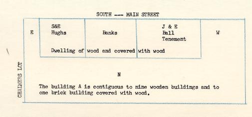
In 1823 Anderson insured his property (policy #5009 revaluation of #1387) thus: "my building on the main street in the said city now occupied by Sally & Eve Hughes and Banks situated between the lot of David Chalmers on the East the lot of John and Elizabeth Ball on the West, and streets on the north and South in the county of York... Dwelling valued at $534."2 This was Anderson's two thirds. The part occupied by the Balls was not insured by Anderson.
In 1821 (March) Anderson rented to William Lee "lower tenement, kitchen, half garden, and joint yard--the rent to be paid to me quarter yearly--$50." (Day Book #8, P. 45) As the rent is the same quoted to Sarah and Eve Hughs the same year--, it is concluded that Lee did not remain in this tenement but a few months.
Anderson's Day Book indicates that Sally and Eve Hughes paid him house rent from August 1821 to August 1823: 19.
Williamsburg September 5, 1821
5- Sally and Evey Hughes-house rent to 1 Jany 1822 f lst--[$]12.50 house rent engaged for the year 1822 q- yearly -------- 50.--
The two Miss Hughes' engaged my house in August at $40- but they afterwards desired me to place shelves, counter, &c up and agreed for my so doing to give me $50 pr year until the end of 1822. I should charge from lst September for rent-but they went in on 1st inst only (stable not included).1
Jany 24, 1823 Cash Account dr To Sally & Eve Hughes recd in part of rent due 1st inst (bal due 2.50) $10.-2
Augst 4, 1823 Cash Account dr To Sally & Eve Hughs recd for ¼ house rent due 1 April last ------ $12.503
We do not know what kind of store was operated by the Misses Hughes. It could have been a general store or possibly a millinery, A retail license of $20 yearly was paid by Sara and Eve Hughs from 1823-1826.4
The building insured by Anderson in 1815 was valued at $1700. In 1823 it was valued at $534. Within eight years, there had been a change in value of $1166. In 1830 it had sunk to $400. We do know what caused this radical change in insurance valuations. There may have been a fire or the changes could have come from deterioration. Property to the east (Lot 58 west) had practically no change in insurance valuations within these years; and the property towards the west (Lot 56) had little change in insurance valuations during this period.5 (See: writer's interpretation, page 20.)
20.The Land Tax Records indicate that Elizabeth Bray1 was conveyed a lot in 1823 via Edward Teagle.
In 1826 Thomas Foster was conveyed this lot via Elizabeth Ball.2 Anderson continued to own the ⅔ part of the lot.
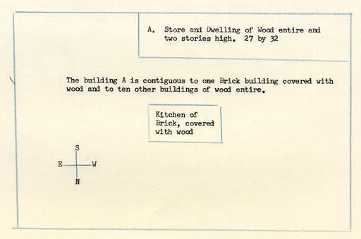
In 1830 according to an insurance revaluation the property was insured as: "...my building on the main street in Williamsburg now occupied by Thomas Moore situated between Morrisons lot on the East, Fosters lot on the West, and streets on the North and the South in the county of York... The Store and Dwelling at $400 of wood entire and two stories high 27 by 32...Kitchen of Brick covered with wood."3
In 1833 Foster conveyed his part of the lot to Robert Anderson making Anderson own the entire lot: "1 lot and building $450; building $350 via Thomas Foster's trustee."4
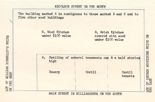
Anderson insured the property in 1838 thus: "... my building on my own land in Williamsburg now occupied by James T. Bowry and M. J. Orrill's representives situated between the lots of George Morrisons estate on the East, William Donnelly's representatives on the West, Nicolson street on the North and the main street on the ------ in the county of York... The Dwelling $1000 of several tenements one & a half stories high; brick kitchen under $100 and wood kitchen under $100."5
By 1838 Anderson, evidently, made changes which increased the insurance valuation to $1000. "Tenements" (divisions) are first noted in insurance 21. policy descriptions in 1838. This may mean that Anderson repaired the old property, discarding the architectural scheme and building a 3-division house.
Anderson continued to own the property. He insured it in 1846 thus: "...my building on my own land now occupied by James Bowery situated between the lot of George Morrison's estate on the East, the lot of William Donnelly's estate West and streets otherwise... The Dwelling $1000 of wood, small brick kitchen and wood kitchen."1
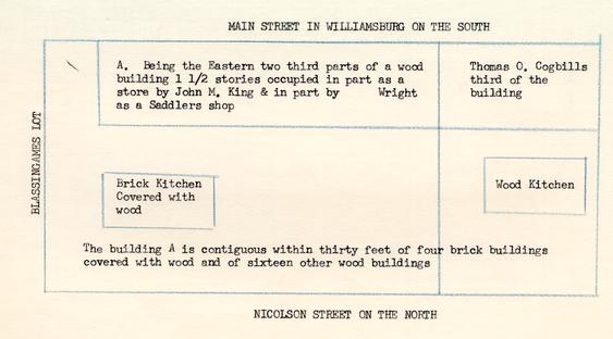
In 1853 Robert Saunders had come into ⅔ part of the property. He insured it thus: "… my portion of Building on the main street-being two thirds parts thereof now occupied by John M King and [W] Wright situated between the other portion of the said building on the West, the lot of Robert Blassingam on the East, main street South and Nicolson street north… The Store $666 ⅔… Being the Eastern two third parts of a wood building 1 ½ stories occupied in part as a store by John M. King & in part by Wright as a Saddlers shop [Thomas O. Cogbills third of the building to the west]; brick kitchen and wood kitchen."2
W. Wright advertised in the VIRGINIA GAZETTE of September 29, 1853, thus: "NEW ESTABLISHMENT IN WILLIAMSBURG, VA. The Subscriber... has opened a shop on Main Street, one door above Mr. John M. King's Store, for the purpose of carrying on the SADDLERY business..." In the same issue John M. King advertised his "house where I now reside [Lot 56] and also for rent, the house where the subscriber occupies as a store..."
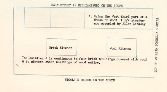
The western part of the property was insured by Cogbill in 1853 thus: "…my portion of Building on the main street-being one third part 22. thereof now occupied by Lindsay situated between the other portion of the said building on the East, the lot of William Donnellys heirs on the West, main street south and Nicolson street on the north… The Cabinet Makers shop $333 ⅓… Being the West third part of a House of Wood 1 ½ stories— now occupied by Allen Lindsey; brick kitchen and wood kitchen."1
In 1860 both portions of the building was insured by each owner, Cogbill's estate insured the one third part thus: "… the said Building is at present owned by The estate of the said Thomas Cogbill decd and is occupied by Mr Woolfolk That it is situated on the North side of Main Street between a tenement of John Blassingham on the East and a Lot on the West in the city of Williamsburg… The School House $333 ⅓…"2 John Blassingham had come into the ⅔ part of the building via Robert Saunders. He insured it thus: "… my building on the North side of Main Street now occupied by Joseph Walthall situated between a Lot on the East & a tenement of Thomas 0. Cogbill's on the West in the said City of Williamsburg… The Store $666 ⅔."3
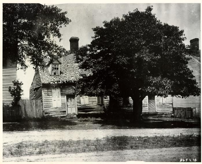
John S. Charles, an old citizen of Williamsburg, writing in 1933 of his recollection of Williamsburg during the Civil War period, had this to say about the buildings then known as the "Red Lion."
On the site now occupied by the new dwelling owned by Mr. Bryhn, and the house next to the Cogbill house, there stood, up to a few years ago, a long one story and half frame building with dormer windows, and two doors opening on the street. The up-town door was the entrance to the part used as a dwelling, and the down-town door was the entrance to the store once kept there. This house was the original "Red Lion", and not the little reddish brick house now at the N. W. corner of Duke of Gloucester and Colonial streets, which in recent years has been erroneously called the Red Lion. This 23. old Red Lion was evidently one of the originals. On account of its age it became dilapidated and a menacing fire trap so it was removed not many years ago.1
Where the house of Mr. Donegan now stands, there stood, until after the War Between the States, a two story frame house with porch on the western front, which was used as a residence; and in the eastern end there was a store for many years, which had the distinction of having been the only store here for a long period of the War.2
Mrs. Victoria lee, another old citizen, gave her impressions of Williamsburg in 1861. Her description of this property follows:
To the west of the old Morrison house was a tiny, frame, story and a half cottage occupied and owned by the Blassinghams.
The Red Lion Inn, a story and a half house, stood a few yards west of the Blassingham house. The Red Lion was a rather long house, three doors opening on the street, This old house had a very interesting interior, I remember a hunting scene painted above the mantel in the west living room. Like so many other houses in Williamsburg, this house was occupied during the war by three families of refugees. The Red Lion was only a few feet east of the house in which I now live.3
During the Civil War, court records of James City and Williamsburg were destroyed by fire in Richmond. Hence it is impossible to fill in legal title to ownership or property changes until several years following that conflict. A deed of 1865 from Miranda Wall conveyed to Maurice Donnegan property which seems to be this lot. We do not know at what date Wall gained the property (probably from Blassingham):
... All that lot of land, including all building, appurtenances and so forth, thereto belonging, situate in the City of Williamsburg, and bounded as follows: On the north by Back Street; on the east by Robert Blassingham's present residence; on the south by Main Street; and, on the west by 24. by Mrs. Cogbill's premises.1
The same day Donnegan conveyed to Talbot Sweeney, trustee, to secure Miranda Wall.2 Two deeds of trust followed in 1872 and 1874. In 1882 the property was conveyed in fee simple to Maurice Donnegan.3 In 1889 the property was conveyed to M. F. Timberlake following a suit by the Mutual Assurance Society vs Maurice Donnegan and John Blassingham as a party defendant. Description of the deed is:
... All that lot of land with the buildings thereon, situate in the City of Williamsburg and bounded as follows: On the north by a public street; on the east by a lot belonging to the estate of J. C. Timberlake, deceased; on the south by Duke of Gloucester Street; and, on the west by the lot of Mrs. Victoria Lee.4
In 1893 it was ordered by the City Council that the building be demolished as it had become a fire hazard.
Jan. 2, 1893.
The street committee are instructed to notify the owner or owners of the old "Red Lyon" to remove the same at once. At least that portion of the house as is now falling down and in a dilapidated condition, the same having been complained of by C. P. Armistead as being dangerous to property thereabouts, should fire by any means be communicated thereto besides being an unsightly object on our principal street.5
25.Jan. 3. 1893.
That after thirty days notice by or from the street committee, that then the street committee shall have power and are so instructed and required to have the house or that certain portion of it removed at the cost and risk of the owners...6
On July 13, 1894, Timberlake conveyed to Edward W. Maynard:
... All that certain lot of land, with the buildings thereon...fronting sixty-nine (69) feet on the Duke of Gloucester Streets and bounded as follows; to-wit: Beginning at a point on the intersection of the eastern boundary of the Cogbill lot now owned by Mrs. Victoria Lee, with the Duke of Gloucester Street, and running thence in a northerly direction along the said eastern boundary, the distance of two hundred and sixty-seven (267) feet to Nicholson Street; thence east along the southern boundary of the said Nicholson Street the distance of sixty-three (63) feet to the lot formerly owned by Mrs. S. E. S. Baker; thence south along the western boundary of said Mrs. Baker's lot the distance of sixty-six (66) feet; thence east along the southern boundary of the said Mrs. Baker's lot the distance of 10 ft; thence south the distance of two hundred and one (201) feet to the northern line of the Duke of Gloucester Street the distance of sixty-eight (68) feet to the point of beginning.1
In 1916 Maynard conveyed the same property to W. Chester Evans.2 Evans promptly conveyed to Peninsula Realty Corporation.3 In April, 1921, the Peninsula Corporation sold to J. H. Pierce a portion of this property--on the north:
Beginning at a point on the intersection of the northeast boundary of the Cogbill lot, now owned by Mrs. Victoria Lee with Nicholson street, and running thence in a southerly direction along the eastern boundary of said Mrs. Lee's lot, the distance of one hundred and three feet (103); thence east, parallel with Nicholson street seventy-three (73) feet to the western boundary of the present Donnegan lot; thence north along the western boundary of the present Donnegan lot thirty-four (34) feet; thence west along the southern boundary of Mrs. S. E. S. Baker's lot, now owned by the grantor, a distance of ten (10) feet; thence north on the western boundary of the said grantor's lot sixty-six (66) feet to Nicholson street; thence west along Nicholson street sixty-two and one-half (62 ½) feet to the point of beginning.4
In 1924 the Peninsula Realty Corporation conveyed to Mrs. George A. Bryn.5
26.On October 26, 1927, Mrs. Bryn conveyed to W. A. R. Goodwin representing Williamsburg Restoration.1
The building has been reconstructed and is now occupied as a residence.
From the study above, we see that there is no justification of calling this property the "Red Lion" until the nineteenth century. In Illustration #5 are copies of two memorandums prepared in February, 1951. One by Mary Goodwin of the Research Department is entitled, "Reasons against locating 'The Red Lion' on colonial lot 57"; the other by Mary Stephenson is entitled "Reasons to believe that 'The Red Lion' was located on lot 44 (now known as Blair's Brick House.)"
Footnotes
Illustration #1
COPY OF TWO MAPS
FROM FRENCHMANS MAP 1782?
FOUNDATIONS UNCOVERED BY ARCHAEOLOGICAL EXCAVATION, MAR. 1940 & FEB. 1942
Illustration #2
Williamsburg Land Tax Records:
| 1782 | Henry Nicholson | 3 lots | £15 |
| 1785 | Henry Nicholson | 1 lot | 5 [Lot 57] |
| William Rowsay | 3 lots | 15 bot of Hen: Nicholson [Richard Bland House] | |
| 1786 | Henry Nicholson | 1 lot | 7. |
| 1787 | Henry Nicholson | 1 lot | 22.10.- |
| 1788 | Henry Nicholson | 1 lot | 22.10.- |
| 1789 | Henry Nicholson | 1 lot | 20.-.0 to Jno Crump |
| 1804 | Jno Crump | 1 lot | $70 |
| 1806 | Jno Crump | 1 lot | 70 |
| 1807 | Robt Anderson | 1 lot | 90 via Crump |
| 1809 | Robt Anderson | 1 lot | 100 via Crump |
| 1815 | Esther Whitfield's Est | ⅓ lot | 50 rent |
| 1816 | Edward Teagle | ⅓ lot | via Ro: Anderson and Helen Maxwell his wife, ⅓ part of a house and lot in Williamsburg and is the same held by Esther Whitfield decd as and for her dower. (Williamsburg Land Transfers) |
| 1817 | Edward Teagle | ⅓ lot | $40 |
| 1819 | Edward Teagle | ⅓ lot | 40 |
| 1820 | Edward Teagle | 1 lot & building | $450; building $350 |
| 1823 | Elizabeth Bray | 1 lot & building | $450; building $350 via Edward Teagle |
| 1824 | Elizabeth Bray | 1 lot & building | $450; building $350 now Elizabeth Ball |
| 1826 | Thomas Foster | 1 lot & building | $450; building $350 via John Ball and Elizabeth his wife who was Elizabeth Bray relict of George Bray decd |
| 1833 | Robt Anderson | 1 lot & building | $450; building $350 via Thomas Foster's trustee |
| 1848 | Jno E. Pierce | 1 lot & building | $600; building $400 Deed from Ro Anderson in 1847 |
| 1850 | Ro: Saunders | 1 lot & building | $600; building $400 from Jno E. Pierce 1849 |
| Thos. O. Cogbill | 1 lot & building | $400; building $350 deed from Ro: Anderson 1849 | |
| 1859 | John Blassingham* | 1 lot & building | $1000; building $800 |
| Eleanor E. Cogbill | 1 lot & building | $450; building $250 Formerly chg to Tho: O. Cogbill transferred under his Will. | |
| 1861 | John Blassingham | 1 lot & building | $1000; building $800 |
| Eleanor E. Cogbill | 1 lot & building | $450; building $250 |
| 1823 | Sarah Hughs | Retail License | $20 |
| 1824 | Sarah Hughs | Retail License | $20 |
| Elizabeth S. Ball | Retail License | $17 | |
| 1826 | Sarah & Eve Hughs | Retail License | $20 |
| Elizabeth S. Ball | Retail License | $17 | |
| 1829 | Elizabeth S. Ball | Retail License | $20 |
| Thomas Moore | Retail License | $20 | |
| 1830 | Elizabeth S. Ball | Retail License | $20 |
| Thomas Moore | Retail License | $20 | |
| 1831 | Elizabeth S. Ball | Retail License | $20 |
| 1834 | Augustine C. Hubbard | Retail License | $20 |
| Martha Orrill | Retail License | $20 | |
| 1837 | Aug: C. Hubbard | Retail License | $20 |
| Martha Orrill | Retail License | $20 |
Illustration #3
[NOTE: Writer does not know on which of Nicolson's lots these repairs were made. Some of it could have been on Lot 57.]
Ms Ledger of Humphrey Harwood, B, page 28| Dr | |||
| 1780 | th | ||
| Jany | 17 | To 8 bushs of lime a 8/ & ½ do hair [blot] & 1 days labr 2/6 | £ -. 8. 9 |
| To 2 days work Mending plastering 12/ | 12.- | ||
| 31 | To Whitewashing 2 Rooms, & a Closet a 3/9 | 11. 3 | |
| 27 | To 100 bricks 2/9 Mending Kitching Chimney 3/9 & labr 1/6 | 7. 9 | |
| March | 18 | To 2 bushs of lime 1/6 hair & mendg plastering 2/8 & ½ day labr 1/ | 5. 6 |
| To Whitewashing 3 Rooms, & A passage a 3/9 | 11. 3 | ||
| 2.16. 6 |
| Cr | |||
| 1785 | |||
| Augst | 10 | By this Account Caried to Mr Henry Nicolson's Account (Folio 41) | £ 2.16. 6 |
[NOTE: Writer does not know on which of Nicholson's property these repairs were made. Some of it could have been to his building on Lot 57.]
Ms Ledger of Humphrey Harwood, B, page 41| Dr | |||
| 1781 | th | ||
| Jany | 18 | To 1 bushel of lime ⅓ & mendg chimy & turning Arch 3/6 | £ -. 4.9 |
| Octobr | 30 | To Cash lent you 13/4. (Decemr 5th) to Mortar & plaster a 6/ | 19.4 |
| no such acct | To Work done to Amount to 56/6 Changed to Mr Ben Weldon as Gardin to the Above Mr Henry Nicholson | 1. 4.1 | |
| 2.16.6 | |||
| 1782 | th | ||
| Septr | 25 | To 5 Bushs of Wheat a 6/ | 1.10.- |
| 1783 | Dr | ||
| Novemr | 11 | To 18 bushels of lime a 1/ & hair 1/6 & 5 days labour a 3/ | £ 1.14.6 |
| To repairing larthing & plastering 30/ & to 40 larthes a 7 | 1.10.7 | ||
| 24 | To 4 bushels of whitewash a 2/ & whitg 1 passage 4/6 & 2 entires 4/6 | .17.- | |
| To whitewashing 3 Rooms a 4/6 & large Room 10/ | 1. 8.6 | ||
| To 4 bushs of lime a 1/ & Repairing plastering in back room 2/6 | 6.6 | ||
| To laying a harth 2/6 & mending a Chimney 2/6 (do) | 5.- | ||
| To whitewashing back Room & Closet 7/6 | 7.6 | ||
| To whitewashing 5 Rooms and 2 passages up Stairs a 4/6 | 1.11.6 | ||
| £ 8. 1.12 |
| Dr | |||
| To Sundries Brought Down | £ 5.10.7 | ||
| 1785 | st | ||
| Augst | 31 | To 32 bushels of lime at 1/ & 668 bricks a 3/ pr C- | 2.12.- |
| To taking down Chimney 25/ | 1. 5.- | ||
| Sepr | 1 | To 18 bushels of lime 18/ & 4 days labr a 2/6 | 1. 8.- |
| 3 | To 15 do of do 15/ & 2000 bricks a 3/ | 3.15.- | |
| To 7 days labr a 2/6 & rebuilding Chimney 70/ | 4. 7.6 | ||
| To 3 days labr a 2/6 | 7.6 | ||
| 14 | To 56 bushels of lime a 1/ & 4 bushels of hair a 2/ | 3. 4.- | |
| 15 | To 28 bushs of do a 1/ & plastering 1 Room (85 Gal) a 3 1/2 | 2.13.8 | |
| To repairg larthing & plastering in the other Rooms 38/ | 1. 8.- | ||
| To laying a Harth up Stairs 2/6 & buildg pair of Steps 7/6 | .10.- | ||
| To 7 ½ days labr a 2/6 & 100 larths 1/6 | 1. 0.3 | ||
| To repairing underpining 2/ & 4 load of sand carted a 1/6 | 8.- | ||
| Octr | 12 | To 1 ½ bushels of Whitewash a 2/ & whitewashg 3 Rooms & 1 passage & Closet a 2/6 | 1. 0.6 |
| 1786 | |||
| March | 7 | To 6 bushels of Oats a 2/6 | 15.- |
| £30. 1.- | |||
| 1788 | |||
| Decr | 10 | To 1 bushl lime 1/ & mendg plasterg & lbar 1/ | 2 |
Illustration #4
No. 585
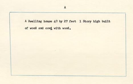
February 19, 1802 Williamsburg
I the underwritten JOHN CRUMP & ESTHER WHITFIELD residing at WILLIAMSBURG in the county of JAMES CITY do hereby declare for Assurance in the MUTUAL ASSURANCE SOCIETY against Fire on Buildings of the State of Virginia... to wit:
My OWN buildings on THE MAIN STREET AT THE SD PLACE now occupied by OURSELVES situated between ROBERT GREENHOW and that of J.W.Dixon in the county of JAMES CITY…
The DWELLINGS marked A at 1000 Dollars…
WE the underwritten, being each of us house-owners, declare and affirm that we have examined the above mentioned property of JOHN CRUMP and that we are of opinion that it would cost in cash FIFTEEN HUNDRED Dollars to build the same.. and is now (after the deduction of FIVE HUNDRED Dollars for decay or bed repair) worth actually ONE THOUSAND Dollars in ready money, as above specified to the best of our knowledge and belief, and he the said subscriber has acknowledged before us his above signiture.Residing in WILLIAMSBURG
THOS SANDS
JOSIAS MOODY
No. 1387
Revaluation of Buildings formerly declared for assurance by JOHN CRUMP and ESTHER WHITEFIEID per declaration No. 585
May 3, 1815
I the underwritten ROBERT ANDERSON residing at WILLIAMSBURG in the county of YORK do hereby declare for assurance in the Mutual Assurance Society against fire on buildings of the state of Virginia MY buildings on THE MAIN STREET IN WILLIAMSBURG situated between ROBERT GREENHOWS LOT ON THE WEST AND JOSEPH HAGUES LOT ON THE EAST in the County of YORK...The DWELLING HOUSE Marked A at 1700 Dollars
…
WE the underwritten being each of us Freeholders, declare and affirm, that we have examined the above-mentioned buildings of ROBERT ANDERSON and we are of opinion that they would cost in cash TWO THOUSAND dollars to build the same, and that now (after deduction of THREE HUNDRED dollars they are actually worth ONE THOUSAND SEVEN HUNDRED dollars in ready money, as above specified to the best of our knowledge and belief. As witness our handsGeo Morrison
Edward Teagle
Ro: Anderson Special Agent
No. 5009
Revaluation of Building formerly declared for Assurance by ROBERT ANDERSON per Declaration No. 1387
April 7, 1823
I the underwritten ROBERT ANDERSON residing at WILLIAMSBURG in the county of YORK do hereby declare for Assurance in the MUTUAL ASSURANCE SOCIETY against fire on buildings of the state of Virginia MY building on THE MAIN STREET IN THE SAID CITY now occupied by SALLY & EVE HUGHES AND BANKS situated between THE LOT OF DAVID CHALMERS ON THE EAST THE LOT OF JOHN AND ELIZABETH BALL ON THE WEST AND STREETS ON THE NORTH AND SOUTH in the county of YORK...
The DWELLING Marked A at 534 Dollars
…
WE the underwritten, being each of us freeholders, declare and affirm, that we have examined the above-mentioned building of ROBERT ANDERSON and we are of opinion that it would cost in cash EIGHT HUNDRED dollars to build the same, and that NOW, (after deduction of TWO HUNDRED AND SIXTY SIX dollars for decay or bad repair it is actually worth FIVE HUNDRED AND THIRTY FOUR dollars in ready money, as above specified to the best of our knowledge and belief. As witness our hands.THOMAS SANDS
RO: ANDERSON Special Agent.
RICHD GARRETT
WILLIAMSBURG
No. 7575
Revaluation of Building formerly declared for Assurance by ROBERT ANDERSON per Declaration No. 5009
May 12, 1830
I the underwritten ROBERT ANDERSON residing at WILLIAMSBURG in the county of YORK do hereby declare for Assurance in the MUTUAL ASSURANCE SOCIETY against Fire on Buildings of the State of Virginia, MY building on THE MAIN STREET IN WILLIAMSBURG now occupied by THOMAS MOORE situated between MORRISONS LOT ON THE EAST, FOSTERS LOT ON THE WEST, AND STREETS ON THE NORTH AND THE SOUTH in the county of YORK...
The STORE AND DWELLING Marked A at $400
…
WE the underwritten, being each of us freeholders, declare and affirm, that we have examined the above-mentioned building of ROBERT ANDERSON that it would cost in cash SIX HUNDRED dollars to build the same, and that NOW, (after deduction of TWO HUNDRED dollars,) it is actually worth FOUR HUNDRED dollars... As witness our hands.RO: ANDERSON Special Agent
THOMAS SANDS
WM M: MOODY WILLIAMSBURG
No. 10992
Revaluation of Building formerly declared for Assurance by ROBERT ANDERSON per Declaration No. 7575
November 27, 1838
I the underwritten ROBERT ANDERSON residing at WILLIAMSBURG in the county of YORK do hereby declare for Assurance in the MUTUAL ASSURANCE SOCIETY against Fire on Building on MY OWN LAND IN WILLIAMSBURG now occupied by JAMES T. BOWERY and M.J. ORRILLS representatives situated between THE LOTS OF GEORGE MORRISONS ESTATE ON THE EAST, WILLIAM DONNELLYS REPRESENTATIVES ON THE WEST, NICOLSON STREET ON THE NORTH AND THE MAIN STREET ON THE in the county of YORK
The DWELLINGS Marked A at $1000
…
We, the underwritten, being each of us freeholders, declare and affirm, that we have examined the above-mentioned building of ROBERT ANDERSON and we are of opinion that it would cost in cash TWO THOUSAND dollars to build the same, and NOW, (after the deduction of ONE THOUSAND dollars,) it is actually worth ONE THOUSAND dollars in ready money, as above specified to the best of our knowledge and belief. As witness our hands this 24th of April 1839RO: ANDERSON
Special Agent
A.G. SOUTHALL Wmsburg
LUCIUS F. CARY
No. 1437
Revaluation of Building formerly declared for Assurance by ----------- per Declaration No. 10992
October 3, 1846
I the underwritten ROBERT ANDERSON residing at WILLIAMSBURG in the county of YORK do hereby declare for Assurance in the MUTUAL ASSURANCE SOCIETY against Fire on Buildings of the State of Virginia, MY Building on MY OWN LAND now occupied by JAMES BOWERY situated between THE LOT OF GEORGE MORRISON'S ESTATE ON THE EAST, THE LOT OF WILLIAM DONNELLY'S ESTATE WEST, AND STREETS OTHERWISE IN the county of YORK...
The DWELLING Marked A at $1000
…
We, the underwritten, being each of us freeholders, declare and affirm, that we have examined the above-mentioned Building of ROBERT ANDERSON and we are of opinion that having regard to its local situation, state of repair, and the present cost of building it is now actually worth ONE THOUSAND dollars in ready money, as above specified, to the best of our knowledge and belief. As witness our hands.RO: ANDERSON Special Agent.
G. DURFEY
JNO M MAUPIN Wmsburg
No. 17647
Revaluation of Building formerly declared for Assurance by ROBERT ANDERSON per Declaration No. 14374
November 14, 1853
I the underwritten ROBERT SAUNDERS residing at WILLIAMSBURG in the county of YORK do hereby declare for Assurance in the MUTUAL ASSURANCE SOCIETY against Fire on Buildings of the State of Virginia MY PORTION OF Building on THE MAIN STREET-BEING TWO THIRDS PARTS THEREOF now occupied by JOHN M KING AND WRIGHT situated between THE OTHER PORTION OF THE SAID BUILDING ON THE WEST, THE LOT OF ROBERT BLASSINGAME ON THE EAST, MAIN STREET SOUTH AND NICOLSON STREET NORTH in the county of York...
The STORE Marked A at $666 ⅔
…
We, the underwritten, being each of us freeholders, declare and affirm, that we have examined the above-mentioned Building of and we are of opinion that having regard to its local situation, state of repair, and the present cost of building, it is now actually worth SIX HUNDRED AND SIXTY SIX & TWO THIRDS dollars in ready money, as above specified, to the best of our knowledge and belief, As witness our hands.RO: ANDERSON Special Agent.
WM S. PEACHY
JNO A DENEUFILLE Williamsburg
No 17626
Revaluation of Building formerly declared for Assurance by ROBERT ANDERSON per Declaration No. 14374
November 28, 1853
I the underwritten THOMAS O. COGBILL residing at WILLIAMSBURG in the county of JAMES CITY do hereby declare for Assurance in the MUTUAL ASSURANCE SOCIETY against Fire on Buildings of the State of Virginia MY PORTION OF Building on the MAIN STREET- BEING ONE THIRD PART THEREOF now occupied by LINDSEY situated between THE OTHER PORTION OF THE SAID BUILDING ON THE EAST, THE LOT OF WILLIAM DONNELLYS HEIRS ON THE WEST, MAIN STREET SOUTH AND NICHOLSON STREET ON THE NORTH in the county of JAMES CITY...
The CABINET MAKERS SHOP Marked A at $333 ⅓
No. 21319
Revaluation of Building declared for Assurance by THOMAS O. COGBILL as per Declaration No. 17726
December 31, 1860
We, the underwritten WALKER W. VEST & PARKES SLATER Appraisers, do hereby certify that we have viewed and revalued the Building heretofore declared for Assurance in the Mutual Assurance Society against Fire on Buildings of the State of Virginia by THOMAS O. COGBILL as per HIS Declaration for Assurance Numbered 17626 That the said Building is at present owned by THE ESTATE OF THE SAID THOMAS O. COGBILL DECD and is occupied by MR WOOLFOLK residing at That it is situated on THE NORTH SIDE OF MAIN STREET BETWEEN A TENEMENT OF JOHN BLASSINGHAM, ON THE EAST AND A LOT ON THE WEST IN THE CITY OF WILLIAMSBURG AND JAMES CITY...
The SCHOOL HOUSE Marked A at $333 ⅓
No. 21315
Revaluation of Building formerly declared for Assurance by ROBERT SAUNDERS per Declaration No. 17647
1860 [no month or day]
I the underwritten JOHN BLASSINGHAM residing at WILLIAMSBURG in the county of YORK do hereby declare for Assurance in the MUTUAL ASSURANCE SOCIETY against Fire on Buildings of the State of Virginia MY Building on THE NORTH SIDE OF MAIN STREET now occupied by JOSEPH WALTHALL situated between A LOT ON THE EAST & THE TENEMENT OF THOMAS 0. COGBILL'S ESTATE ON THE WEST IN THE SAID CITY OF WILLIAMSBURG AND in the county of YORK...
The STORE Marked A at $666 ⅔
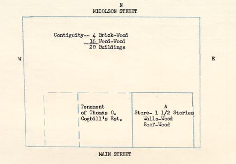
Illustration #5
To: Mr. Middleton
From: Mary Stephenson
Re: Red Lion in Williamsburg
In working on Philip Ludwell's lots in Williamsburg which descended to William Lee and John Paradise, I ran into evidence which seems to prove that the Red Lion tavern was not located on lot 57 as hitherto supposed but was on lot 44 north side of Duke of Gloucester Street, which lot was the property of John Paradise via Ludwell's estate.
/s/ M. A. S.
M. A. S.
LOCATION OF "THE RED LION"
Reasons to believe that "The Red Lion" was located on lot #44 (now known as Blair's Brick House) are given below:
Proof that the Red Lion was located on lot #44 hinges on the fact that John Paradise owned the "Red Lyon" as part of his inheritance via Philip Ludwell, father of Lucy Ludwell Paradise. In making a division of Ludwell's property in 1770, "Mrs. Paradise's Part," was noted thus:
(Lee Ms., Virginia Historical Society.)
"Rich Neck ... Houses & Lotts in Wmsburg viz The tenement adjoing the Speaker1 £125 Red Lyon Powels Tenement2 10"
In 1768 Walter Lenox, barber and wig-maker, announced in the Virginia Gazette that he had moved "to the house known by the name of the Red Lion, next door above Mr. Rind's Printing Office, where he carries on his business in all its branches, as usual, and ... has good accomodations for private lodgers..." In July 1770 Richard H. Lee wrote his brother, William Lee in London that "the large brick house that Rind lives in3 ... fell to your share" in the settlement of Ludwell's estate. (Lee had married Hannah Ludwell and - as did Paradise - inherited three of Ludwell's houses in Williamsburg also.)
In the General Court Records is an indenture of November 6, 1770 in which Ludwell's lots in the city assigned to Mrs. Paradise were described thus:
"... also the following lots of land or tenements in the city of Williamsburg to wit one tenement adjoining the Speakers one tenement called the red Lyon where Walter Lenox now lives and the tenement where Peter Powell now lives adjoining the Blue Bell tenement ..." (Southall Ms. Papers, Uncatalogued, William and Mary College.)
In 1779 an inquisition for the Commonwealth of Virginia was held in York County as to the right of Paradise, not a citizen of Virginia, to land and lots in Williamsburg:
"... likewise three houses & lots in the City of Williamsburg; north main street adjoining William Lee (who owned Paradise House], now in possession of Walter Lennox, lot on north side of Market Sq. adjoining lots of Mrs. Betty Randolph & lot of Wm Lee, now in possession of Mr. Harrison Randolph; the third in possession of Peter Many (houses and lots) on the street leading to Capitol Landing Road & adjoining the Lot of William Lee, Esq."2
From the above sources, we see that Mrs. Paradise was allotted the "Red Lyon" as part of her inheritance from Philip Ludwell, her father; that Walter Lenox, barber and wig-maker, rented the "red Lyon" in 1770 and undoubtedly was there in 1768 (see "Reasons against locating The Red Lion on colonial lot #57" attached to this memorandum); and in 1779 the lot was described as "north main street adjoining William Lee, now in possession of Walter Lennox," In 1778 an account of Humphrey Harwood, made out to "Mr Cary Wilkinson for Mr Paradise Dr To 10 bushels of lime 75ps & ½ do of hair 2 2/2 for W. Lenox ... £-.17.-." This seems to indicate that Lenox was occupying property of Paradise and repairs were made for his benefit.
The Williamsburg land Tax Records beginning in 1782 show that John Paradise's Estate held three lots in Williamsburg valued at £7, and William Lee's Estate held three at same valuation
M. A. S.
Reasons against locating "The Red Lion" on colonial lot #57:
Briefly, if the "Red Lion" was ever located on lot #57, that lot must have been owned prior to 1767 by Philip Ludwell, and must have passed to Lucy and John Paradise by 1770.
According to available records, lot #57, originally owned and built upon by Francis Sharp, 1717-1740, passed to his son John Sharp, who, in 1742, sold it to Henry Wetherburn. Wetherburn died ca. 1760, and left his property to his widow and nephew Edward Nicholson. His widow claimed her share, and Nicholson owned the remainder, including #57, after 1761. Nicholson is noted as the owner of lot #57 in 1773 and 1779, in deeds to adjoining property. In 1787, Henry Nicholson sold lot #57 to Samuel Crawley. (See research report on "Red Lion" block 17, lot #57, pp. 1-8.)
Therefore lot #57 could not have been involved in the settlement of Ludwell's estate in 1770.
Two advertisements in the Gazette refer to the "Red Lion" - neither of them locating the building. In 1766 a Stephen Buck, tailor, announced that he was moving "from the Red Lyon." (Purdie & Dixon, Nov. 6. 1766.) In 1768, a Walter Lenox Perukemaker announced that he had "moved to the house known by the name of the Red Lion, next door above Mr. Rind's Printing Office." (Ibid., March 24, 1768.) The possibility that Rind's printing office was at one time adjoining lot #57 was based on his earlier location as given in his first Gazette and subsequent Gazettes in the year 1766: "WILLIAM RIND, at the NEW PRINTING-OFFICE, near the CAPITOL." (May 16-Sept. 5, 1766. Papers missing between that date and February, 1767.) However, Rind moved his printing office; for in the issue of Feb. 19, 1767, he advertised his location: "at the NEW PRINTING-OFFICE, on the main street, where Joseph Pullett lately kept Tavern." (Ibid., Feb. 19.. 1767.) The location continued to be so given for several weeks, and then was shortened to "at the New Printing-Office on the main Street." The printing office continues "on the main Street" throughout the remainder of Rind's life.
Joseph Pullett had a tavern in Williamsburg in 1766 at which the king's birthday was celebrated by "his Honour the Governour, with some of the principal Gentlemen" who "spent the evening in honour of his Majesty." Pullett died, probably early in 1767 - for his personal property was sold to pay his debts in the spring of that year. An inventory of his personal estate was filed in the York County Records. He did not own his tavern - and could well have leased the Paradise House, prior to Rind's occupancy of it. We do not know when Rind moved to this building - we know that he and his family occupied it by 1770-1774 and he may have followed Pullett's possible occupancy.
M. G.
[Illustration #6]
JOHN CRUMP
Crump Family in Virginia:
The Crump family were represented in Virginia at an early date. Thomas Crompe (or Crump) was a burgess for James City in the General Assembly of 1631/2, and was burgess for Neck of Land in 1631/2. John Crump owned 1,250 acres of land in James City County in 1654. In 1656 William Crump patented land in that county.1
In 1752 a John Crump was living in the part of Prince William County which later became Fauquier County, and served as a justice in both counties.2 In 1769, a John Crump, son and heir of Nathaniel Crump, lived in New Kent County.3 Many of the early Virginia county records have disappeared--among them those for James City County and New Kent County. However, in county records that have survived, wills for members of the Crump family are filed in Accomac, Bedford, Cumberland, Fauquier, Lancaster, and Powhatan Counties4 between the years 1667-1796.
In Williamsburg:
A John Crump was a cabinetmaker in Williamsburg in 1775. Because of the loss of the James City County-Williamsburg court records for that period, we are unable, through wills and deeds, to properly identify or locate him. The name does not appear in the York County records until later, so if he owned property in Williamsburg (as he did by 1782), it must have been in the James City County portion of the town. In any case, the following notice appeared in the Virginia Gazette in January, 1775:
"WILLIAMSBURG, January 12, 1775.
WANTED, by the subscribers,
TWO or three JOURNEYMEN CABINETMAKERS, to whom good wages will be given. We have a good stock of seasoned mahogany and black walnut by us, and will work cheap for cash, or short credit.
RICHARD BOOKER.
JOHN CRUMP."5
In 1778 Mr. John Crump of Williamsburg was mentioned in an advertisement concerning a missing horse,6 and in 1779 John Crump offered a reward for the return of a horse of his own which had been stolen from him in Williamsburg.7
2.In 1789, and probably earlier, John Crump was jailor in Williamsburg. In January of that year Edmund Randolph wrote from Williamsburg to Governor Beverley Randolph of Virginia, in behalf of "sundry gentlemen," who recommended John Crump, present "Jailor of the City of Williamsburg [as] a proper person to be Keeper of the Jail belonging to the District Court."8 In August of the same year, "John Crump, Jailor" advertised that he was holding two runaway negroes in the Williamsburg jail.9
In the Williamsburg Tax Records, which have survived from 1782-3 on, we learn that a John Crump and a Richard Crump owned personal property and lots in Williamsburg in 1782. As neither name appears in the York County Records at that time, they must have lived in the James City County portion of the town. We do not know their relationship. In any case, in 1782, Richard Crump was taxed for 1 lot in Williamsburg (valued at £3) and John Crump was, taxed for 2 lots in the town (valued at £6:l5:0). John Crump in 1784 also paid personal property tax on three slaves (one over 16 and two over 12 years of age) and on 2 horses and 2 cattle. In 1790 John Crump was taxed for three lots, the three valued at £27. This third lot was doubtless the lot which he acquired from Henry Nicholson in 1789--Colonial Lot 57. In 1790 one slave was charges against John Crump's estate. The three lots were charged against John Crump's estate through 1803.10
Another John Crump's name replaced "John Crump's estate" on the tax records.11 He was probably the deceased Crump's son...By 1799, John Crump was taxed for one slave over 16 years of age. In 1799-1801 a John Crump obtained shop licenses; and in 1805 John Crump obtained an ordinary license, which he renewed in 1806. By 1805,the three lots (valued since 1799 at $90) had disappeared from the land tax list against John Crump's estate, and John Crump was charged with 1 lot valued at $70. We believe that this was the lot (colonial lot #57) which the earlier John Crump obtained from Henry Nicholson in 1789. In August, 1806, Robert Anderson gave John Crump a deed of trust on this lot, on which Crump then resided. Anderson rented the house, which was referred to ca. 1808 as "Union Tavern", to Crump until December, 1809, after which Anderson took it over himself.12
Colonial Lot #57.
To sum up the Crump association with Colonial lot 57, John Crump [Sr.?] purchased the lot and buildings from Henry Nicholson in 1789. He was probably the John Crump who was a cabinetmaker in Williamsburg in 1775, and who by 1782 owned two lots, apparently in the James City portion of town. He may have been the John Crump who was jailor in 1789.
3.There are accounts for minor repairs and whitewashing against John Crump in Humphrey Harwood's ledgers in 1784 and 1789-90, and the latter may have concerned the building on lot 57.13 John Crump, owner of three lots in Williamsburg, died in the latter part of 1789 or 1790, his estate being taxed for the three lots through 1803. In 1805, and until mortgaged and subsequently sold to Robert Anderson, one lot (obviously colonial lot 57) was charged against John Crump, possibly son of the deceased. This John Crump occupied the property earlier. He insured it with the Mutual Assurance Company in 1802, as being occupied by himself and Esther Whitfield.14 The policy described the building as being of wood, one story high, 40 x 27 feet, valued at $1000. As he obtained shop licenses in 1799-1801, Crump may have operated a shop at first. In 1805 and 1806 he obtained an ordinary license;15 and the property was described in an insurance policy to an adjoining building in 1806 as "John Crumps Tavern."16 He mortgaged it to Robert Anderson in 1806, but continued to lease and operate it until December 1809, after which the tavern - then known as "Union Tavern" - was taken over by Anderson.17 In 1805, John Crump (who had been taxed since 1799 for one slave) was taxed for 1 white male over 16, three blacks over 16 and three under 12, 2 horses, and 1 ordinary license. In 1806 he was taxed for 3 blacks over 16, 1 horse, and 1 ordinary license. In 1807-1809 he was taxed for 1 white male over 16 years, and his name disappeared from the tax lists after that.18
The names of Richard Crump and a William Crump remained on the Williamsburg tax lists until 1815--after which no Crumps were listed.
MG
10/10/56